


Update: Although wildfires continue in the north, SaskPower reports that as of 1:30 this morning (Wed) all power had been restored in Dillon, La Loche, Buffalo River, St. Georges Hill, Michel Village and the surrounding areas. The power went out Sunday afternoon after about two kilometres of power line was burned.
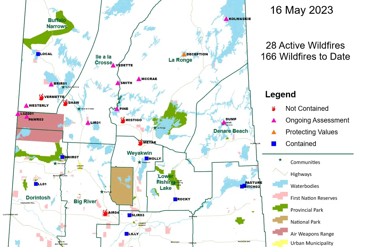
The Saskatchewan Public Safety Agency is reporting 28 wildfires were burning in northern areas of the province—but only five have yet to be contained.
These include the two fires in the Dillon area—west of Buffalo Narrows. The Vermette fire (southwest of Dillon) now covers 45,000 hectares or 111,000 thousand acres. Helicopters with buckets are being employed to prevent further fire expansion. The Shaw fire (southeast of Dillon) is 47,000 hectares or 116,000 acres. Crews have been establishing a dozer guard to secure the fire perimeter. S
Another fire to monitor is in the Besnard Lake area, about 410 kilometres north of Saskatoon. The Public Safety Agency is advising people to avoid travel in the area. The fast-moving fire could threaten the only road into and out of the area.
Further south, a widespread fire ban has been issued for all Crown land and Provincial Parks north of Highway 16. Open fires, controlled burns and fireworks are all prohibited.
Additional information on each of the uncontained fires can be viewed below:
23BN-VERMETTE (Southwest of Dillon)
Current Size: 45,000 ha.
Resources: Type 1 Crew Members, Type 2 Crews, Heavy Equipment, Helicopter Support, Air Tanker Support
Communities<20km: Dillon, St. George’s Hill, Michel Village
Crews continue to work on the northeast flank of the perimeter and have helicopters bucketing to prevent fire
expansion. Will continue to use the water tenders to action any spot fires and the dozers to expand and complete the
fire guards. Crews will be put in place on the line when the conditions are safe and will continue to maintain the values
protection units that are up around the hamlet. Winds have shifted to north, northwest which is favorable.
23LX-SHAW (Southeast of Dillon)
Current Size: 47,010 ha.
Resources: Type 1 Crew Members, Type 2 Crews, Heavy Equipment, Helicopter Support, Air Tanker Support
Communities<20km: Buffalo Narrows
Values in Area: Highway 925, SaskPower Infrastructure
With the northwest winds it is expected to have poor visibility in the area. Crews will be setting up and servicing value
protection units on the Churchill river and Rosser bay areas. Crews will be continuing to establish a dozer guard to
secure the fire perimeter. Support SaskPower crews with their infrastructure in the area.
23LX-SMITH (North of Pinehouse)
Current Size: 42,501.6 ha.
Resources: Detection Aircraft, Detection Unit
Values in area: Highway 914
Fire has breached highway 914. Aerial detection is not available due to visibility in the area. Fire is currently being
monitored by the Wildfire Detection Unit and Detection Aircraft when required.
23LA-WISTIGO (Southeast of Pinehouse Lake)
Current Size: 11,000 ha.
Resources: Type 1 Crew members, Type 2 Crews, Heavy Equipment, Helicopter Support
Values in area: Highway 165, Highway 910, Besnard Correctional Camp, Besnard Lake Lodge
Crews will complete value protection setups on cabins. Putting together a plan for the south end of Besnard Lake. The
fire will be monitored for potential indirect attack opportunities, areas are being assessed for building a fire line.
23WY-MEYAK (North of Weyakwin)
Current Size: 1,560 ha.
Resources: Type 1 Crew members, Type 2 Crews, Heavy Equipment, Helicopter Support, Air Tanker
Support
Values in area: Highway 165, SaskPower Infrastructure
Crews will be working on the NE and SE flanks with dozers. Helicopter support will be working on the east end of the NE
corner. Crews will be working on hotspots as well as setting up and maintaining value protection units